


JOHN McNAMEE TALKS TO A DEDICATED HISTORIAN AND CURATOR
The impressive-looking memorial cross was hewn from the timber ruins of a destroyed cathedral near the village of Pozieres in France during the dark days of the World War I Battle of the Somme.
It carries a simple dedication: IN LOVING MEMORY OF THE OFFICERS, NCO’S AND MEN OF THE 19TH BATT. AIF KILLED AT POZIERES…1916.
Since 1934 the cross has had pride of place in the Anglican church of St Luke’s in the Sydney beachside suburb of Clovelly, a gift from the local branches of the RSL.
In July this year, St Luke’s held a moving commemorative service on the centenary of the bitter fighting in Pozieres during which thousands of Australian troops were killed or died of their wounds.
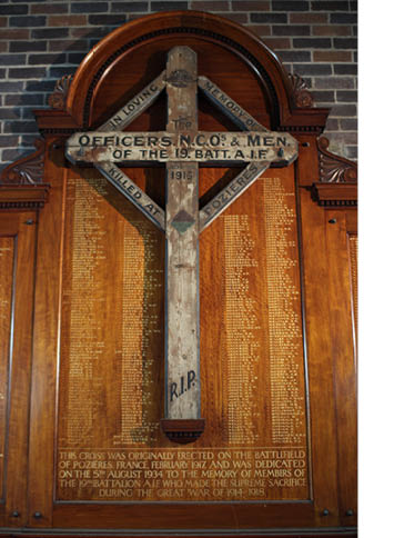
The Cross of Pozieres holds pride of place in St Luke’s Anglican Church in the Sydney beachside suburb of Clovelly.
In the words of official historian Charles Bean the ridge of Pozieres “is more densely sown with Australian sacrifice than any other place on earth.”
Despite the horrendous casualty list, the battle was ultimately successful as it secured the region and placed nearby German artillery encampments under threat.
This battle and the entire history of World War I is also featured in an amazing new book just published called “Where Are Our Boys? How Newsmaps Won The Great War.’”
It represents the culmination of an epic three-year research saga for Dr Martin Woods, Curator of Maps at the National Library of Australia in Canberra.
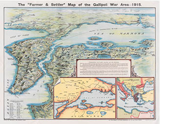
There are more than 200 illustrations in the book comprising maps, newspaper articles propaganda photographs and period cartoons.
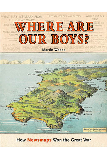
The cover of the book…Where are our boys?
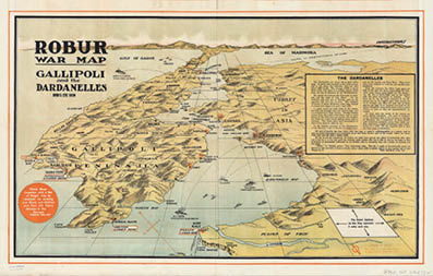
The maps in particular attempt to tell the story of where the Australian troops were fighting and what were the all-too-few victories and the numerous disasters.
“During that time and due to the wartime censorship, people at home could only guess where their sons, fathers and brothers were based so maps were drawn up to help people try to understand what was happening,” Dr Woods told Go55s.
“As the war went on, the whereabouts of our boys were being discussed over these improvised newsmaps as they were called in homes, pubs, churches and clubs.
“Admittedly they were drawn from scant news cables, heavily censored, out of date cartography and often the writer’s imagination.
“But a semi-fictional war story emerged of Anzac successes and sometimes catastrophes,” he said.
“Of course a lot of the illustration was propaganda and the real horrors of what was happening in Gallipoli and later the Western Front were never documented in official news releases.
“During the early stage of the war, the casualty toll was rising alarmingly and the authorities needed the propaganda to recruit more Australian men to fight in the trenches.
“Families for example who had sent their eldest son were now being urged to send their second and third sons.
“To provide some comfort to these people, the war maps were inclined to focus on the heroic victories which were happening elsewhere.
“Also for example, maps of the Gallipoli peninsula began carrying Aussie place names such as Dobbins Post and Quinns Post and even Anzac Cove which provided some recognition for people at home.”
Major newspapers around the country began carrying the newsmaps, battlefield sites and “aerial views” in special supplement editions and hundreds of thousands of them were circulated throughout the nation.
“Sadly there are not too many left but we have been able to secure some and include them in the book.
“Some are very moving and have been lovingly kept through generations of the one family because they held a special place for those who lost loved ones,”
Dr Woods said that during the latter stages of the war, when thousands of injured soldiers were returning home, the true picture and the full scale of the death and injury toll began to emerge.
“People were now being sickened by the realities and started to feel deep resentment against the various publications and site maps of the battlefield areas which told a different story to what they were then being told,” he said.
“For example in November 1918 there was uproar outside the Sydney Town Hall when a large angry crowd began to tear down the war maps which during the war were displayed on all major buildings and shops.
“As well there was almost another riot in 1915 outside the Argus newspaper office in Melbourne which had been posting newsmaps from Gallipoli on their poster boards and where the crowd demanded they be pulled down because they were hearing a different story,” he said.

Dr Martin Woods, curator of maps at the National Library of Australia…..spent three years researching his highly colourful war maps book
The newspaper had published a letter in October 1915 which had been sent to his mother by army surveyor, Captain Leslie Hore who described all the horror of the battle of The Nek.
He wrote: “Truly we have been through the Valley of the Shadow of Death as our regiment has been cut into pieces and all our officers killed or wounded except two.”
As the book states: Hore concluded his harrowing account with the words “And so perished the 8th Light Horse”.
“When he returned to his home in Ararat in western Victoria Captain Hore published a special news sheet with detailed maps outlining the real horrors of what went on in Gallipoli and it came as a tremendous shock to the public,” Dr Woods said.
Dr Woods said that in the book he wanted to trace the narrative of the Great War using all the illustrations and maps and front page articles from the time to paint a far more accurate picture of the time.
“I wanted Where Are our Boys? to provide a different view of World War I using the maps reproduced in newspapers on the home front.
“Maps became central to commemorating events, people and places and helped readers to understand the conflict and comprehend the human cost of war,” he said.
“It was the day to day telling of the war, some of it quite fictitious of course, due to the censorship but it provided an important link.
“The past three years during which I have been involved in this project has made me realise just how important the maps were and I felt that over the past decades they haven’t received the sort of publicity they should have…that’s why I embarked on this venture and especially in these centenary years,” Dr Woods said.
Where Are Our Boys? How Newsmaps Won the Great War by Martin Woods. NLA Publishing. Released August 2016. RRP $AU49.99.